|
 |
Routes to Mt. Kailasa
. The Indian
route is briefly described in Kumoan Vikas Mandal Nigam's website: www.kvmn.org .
The Government of India website that gives details of Indian route is www.mea.nic.in .
One finds very good descriptions as well as helpful information on Tibet in general and western Tibet in particular in the
tourist guide books published by Lonely Planet. More details are in the lonelyplanet website:www.lonelyplanet.com
The Tibetan phrase book published by them is excellent. There are several good books on how Mt. Kailasa was 'discovered'
by the westerners. And more so about the legendary Swami Pranavananda who in his travels in the early 20th century,
kept the measure of all the distances with the beads even as travel there was very difficult and dangerous.
|
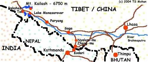
| The Route Map to Mt. Kailash via Kathmandu | |
|
|
This hand drawn map is neither accurate nor correct. The total
distance from Kathmandu to Mt. Kailash is about 900 kms. Driving on dirt tracks
and mud 'roads' one reaches Lake Manasarovar after 6 days. The River Brahmaputra is crossed before Saga.
|


|
Our Itinerary
Summer in the Himalayas and Tibet ensures long daytime hours and short nights. So the day breaks around 5am IST and will
not be dark until about 7.30 pm.
Remember, Nepal is 15 min ahead of Indian Standard Time (IST) and Tibet two and half hours ahead of IST (Beijing Time).
Hence local reference to time could be skewed - evening twilight around 9 pm local time.
This is the itinerary that we completed during our journey. We started from Kathmandu on Monday 26th July around
5 am and returned on 7th August 2004 by 9 pm. It was a hustled up schedule because we had got delayed
for a few days initially and we had a hard deadline - to reach Kathmandu before 8th August to catch the flight out. Note that all altitudes as well as distances mentioned herewith is just approximate.
.
Day 1: Monday July 26th 2006. Started from Hotel Gangjong at about 5 am. Drove for about 100 kms by bus (5 hrs) to Kodari (1600m).
Crossed the border. Got into Land Cruisers. Drove 5 kms to Zhang-mu (1900m). Overnight stay in a village Inn.
Day 2: Started late. Drove 40 kms to Nyalam-mu (3800m). Overnight stay in a village Inn. Should have acclimatized for atleast 24 hours. But was there only for about 14 hours.
Day 3: Started at 4 am. Drove 230 kms (8 hours) to Saga (4700m). Crossed the 'Sishama La' pass (5120m) enroute.
Later in the day, crossed the River Brahmaputra by ferry. Overnight stay in tents after the town..
Day 4: Drove 290 kms (about 9 hours) to Paryang (4540m). Beautiful plateau. Overnight stay in tents after the town.
Day 5: Drove 270 kms (about 8 hours) to Lake Manasarovar. (4,740m). Reached around 4pm. Start the Lake Parikrama.
Visited Gompas along the way. Drove along Rakshas Tal for a couple of hours. Wonderful Shravan Purnima sight over the lake . Overnight stay in tents at Chiu Gompa on the banks of the Lake.
Day 6: Took holy dip in the Lake. Puja time. Meditation time. Soaked into the spiritual ambience.
Late afternoon, drove 35 kms over the Parkha Plains to Darchen (4700 m). Overnight stay in the village Inn.
Day 7: Drove 6 kms to 'Tar Po Che'- the Valley of Gods - along river 'Lha Chu' and started the
Kailasha parikrama. Trekked for about 5 hours and 16 kms along the banks and reached Dheerpuk Gompa (4850m). Overnight stay in tents.
Day 8: Early in the morning, started the parikrama. Climbed to cross Drolma Pass (5650m) by noon.
Came by Gauri Kund and crossed the glacier. Descended down and reached the 'Lham Chu' river valley. Treked for another 5 hours to
reach Zutulpuk Gompa (4790m). Covered 22 kms. Overnight stay in tents.
Day 9: Completed the parikrama trekking about 15 kms and 5 hours along the Lham Chu river
until it reaches the Parkha plains. Then drove to Hor Chu along the Lake Manasarovar. Puja and Meditation at Hor Chu. Overnight stay in tents.
Day 10: Drove to Paryang. Stayed overnight in a village Inn due to inclement weather and truck problems.
Day 11: Drove to Saga. Stayed overnight in a town Inn due to inclement weather and soggy camp grounds.
Day 12: Started late from Saga. Delayed at the ferry crossing. Started driving in the evening around 530 pm.
Overnight drive! Reached Nyalam-mu at 2 am. Stayed rest of the night in a village Inn.
Day 13: Drove to Zhang-mu. Completed immigration and crossed over to Kodari by 2 pm.
Drove to Kathmandu to reach Hotel Gangjong by 9 pm August 7th 2004.
|
|
|
The Kailasha Manasarovar Yatra
The Kailash Manasarovar Yatra can be undertaken by Indian Pilgrims via two routes: the Indian
route via Kumaon in Uttaranchal Pradesh, India and the Kathmandu route. Pilgrims from the rest of the
world have the only option of going via Kathmandu.. It is very advisable that the Indian Pilgrims
fully explore and attempt going along the Indian route first before going by the Kathmandu route.
Pilgrims who have done both within a span of month (june and july 2004) have reported vastly greater satisfaction, more
trekking (and healthy acclimatization) via very scenic and inspiring trails in Uttaranchal, better organization,
more time to spend
(a total of 7+ days) in Kailash / Manasarovar and at lesser cost.
Note that for the Indian route, the Indian Government will not entertain people who have already
completed a yatra to Kailash by whichever route as there are set quotas of pilgrims every year and
there are too many people competing for a chance. In addition, only the robustly healthy and medically fit
qualify through the rigourous selection process. If you get a chance on application, consider
yourself very lucky. Yes, there are constraints like you cannot travel with your select group, the total
yatra time is more than 25 days (ex. New Delhi) and the bureaucracy looks dominating. Applications
are invited during Feb/Mar every year (advertised in major newspapers as well as the government
website -Ministry of External Affairs, Govt of India) and the screening procedure
will look daunting. Persist through and you might succeed.
All this only indicates that the urge and the preparations for doing the Yatra spans several months
(or perhaps atleast a year). And several factors need to fall in place for the successful completion.
Needless to say, the first is the inner call along with the blessings of the Lord for a smooth ride!
Typically the yatra is done such
that one is at the Manasarovar on a Purnima day (Full moon day). And the most auspicious purnima is
one in the month of Shravan (July-Aug) This date with the Moon is synchronized so that one
will be at Manasarovar either before doing the Parikrama of Kailasha
parvata or after it. The yatra programmes are open from May end through August end
every year. Early June is pretty cold while August is rainy though relatively warm during the day.
The temperatures are just about right in July end and early august - warm days (30 degrees celsius under
the sun and about 18 degrees in the shade) and relative
better but still cold nights (with a minimum of about 6 degrees celsius).
There can be several disruptions (landslides, overflowing rivers, roads cut and washed away, rains
making everything messy and soggy) during the Sravana Purnima yatra.
| The Route Map to Mt. Kailash via Uttaranchal in India | |

|
|
This hand-drawn map is neither accurate nor correct. There
is a considerable and very nice trek for the pilgrims along the India Nepal border and along River Sarayu (Sarda)
before entering Tibet. Several temples of Lord Shiva dot the trail within India.
|
The India organized yatra starts at New Delhi. After a overnight bus ride, the trekking formally starts at Dharchula. The Indo-Tibetan
Border Police formally checks the medical fitness once more near the border before allowing the yatris to climb to Navidhang. The
chinese take over at the border. Again travelling by bus one reaches Darchen within six hours after a day's stay at Taklakot.
The group splits so that one group
can do the Kailash parikrama while the other does the Manasarovar Parikrama. In all, yatris get to stay there for about 7 days.
The yatra via Kathmandu is described in brief in the side box and in detail later.
|
|